

By PA Reporters
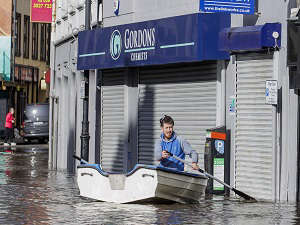
Sections of the Co Down city of Newry are under water following a night of heavy rain.
The scenes come after an amber warning for rain in Northern Ireland overnight, just ahead of the expected arrival of Storm Ciaran across the UK and Ireland on Wednesday.
Newry’s canal burst its banks, flooding Sugar Island, Kildare Street, Canal Quay and part of Bridge Street.
Police have advised people to avoid Newry city.
Just across the Irish border in Co Louth, a bridge close to Riverstown partially collapsed amid rising waters on the Cooley Peninsula, and there was flooding in Co Wexford.
Newry resident Desy Heatley described the scenes as a “repeat of what happened here around 35 years ago”.
“We were up and down here in boats,” he said.
“It’s pretty bad, I’m sure all the shopkeepers are raging, we’d no warning or nothing.”
A Met Office amber rain warning covering counties Antrim, Down and Armagh lifted at 9am.
A yellow rain warning covering large parts of the region remains in place until 12pm while a yellow warning for the whole of Northern Ireland comes into effect at 9pm on Tuesday and lasts to 9am on Wednesday.
Elsewhere, roads have been closed due to flooding, while train passengers on the main Belfast to Dublin route faced significant disruption on Tuesday due to flooded tracks between Portadown and Newry.
South of the border, a yellow rain warning issued by Met Eireann covering Louth and Monaghan expired in the early hours of Tuesday.
Garda warned of flooding on the N1 motorway in Co Louth on Tuesday and also on the R173 in the nearby Carlingford area.
A 24-hour yellow rain warning for Co Kerry in the south west of the island comes into effect at 12pm on Tuesday.
Ireland’s Environment Minister Eamon Ryan expressed concern for those caught up by the flooding.
“My heart goes out to those up in Cooley, Carlingford, down in Wexford I know there has been particular flooding, as well as Newry, as well as what happened to Middleton (Co Cork) obviously a few weeks ago,” he told RTE Radio One.
Stormont’s Department for Infrastructure had warned of inevitable localised flooding in Northern Ireland.
“It may be necessary to close roads or put temporary restrictions in place,” the department said.
The Police Service of Northern Ireland had urged people against travelling during the period of the amber warning overnight.
Across the UK the Environment Agency has issued more than 25 flood warnings ahead of the arrival of Storm Ciaran on Wednesday, while the Met Office has issued yellow weather warnings for rain from Monday until Thursday.
Gusts of 80mph are possible along the south coast of England, with 20 to 25mm of rain expected across southern and western areas, but potentially up to 40 to 60mm over higher ground, the Met Office said.
The forecaster advises the latest rain could lead to disruption on roads and to public transport while already flood-affected areas after Storm Babet could get worse.
Marco Petagna, a Met Office meteorologist, said: “We’ve had various warnings in force across the UK over the last few days, and there are plenty more being issued for the next couple of days.
“The main focus in the next day or two is towards the east of Scotland and north-east England, where there is a yellow rain warning until 3am.
“There will be persistent rain up there, and then the focus for heavy showers will be across parts of southern and south-eastern England and South Wales as well as parts of Northern Ireland with some heavy and sudden showers.”
He said Tuesday was expected to be still unsettled but quieter before heavy winds and longer spells of rain develop on Wednesday into Thursday as Storm Ciaran arrives.
“There are possible gusts of 80 to 90 miles an hour in some exposed southern areas. It’s probably quite a nasty storm this one.”
Kate Marks, flood duty manager at the Environment Agency, said: “We urge people to stay safe on the coast and to remember to take extreme care on coastal paths and promenades.
“Flooding of low-lying coastal roads is also possible and people must avoid driving through floodwater, as just 30cm of flowing water is enough to move your car.”
Met Office deputy chief meteorologist Chris Almond said: “Winds associated with Storm Ciaran are likely to gust to 80mph along the south coast of England, with a small risk of somewhere exposed seeing 90mph, and winds could even gust up to 50 or 60mph further inland.
“This deep, low-pressure system will also bring heavy rain to much of the UK, but the heaviest rain is expected in southern and western areas, with 20 to 25mm quite widely across the region but up to 40 to 60mm potentially over higher ground.
“Heavy and persistent rain will fall on to the already saturated ground, bringing a risk of further impacts such as flooding in areas that are already struggling to clean up from the heavy rainfall we have seen over the last week or so.
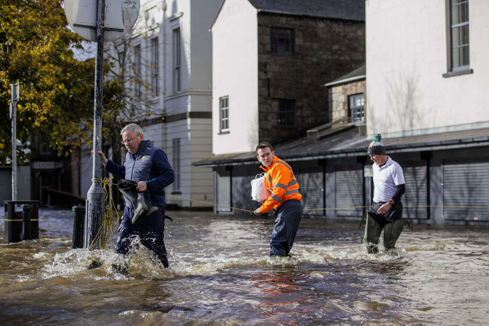
People walk through flood water on Bank Parade in Newry Town, Co Down. Flooding was reported in parts of Northern Ireland, with police cautioning people against travelling due to an amber rain warning. The Met Office warning for Northern Ireland is the second highest level and covers Counties Antrim, Down and Armagh.
 Noah Donohoe inquest adjourned after three days of jury deliberations
 PSNI chief constable warns against ‘wild speculation’ about Jeffrey Donaldson
 Pensioner arrested in connection with the 1973 murder of Marian Beattie
 Poots says he has ‘nothing to answer for’ over Donaldson concerns
 Man dies following road crash in Co Fermanagh
Comments
Add a comment